Trail Walking Vallorbe - Quellen-Rundweg - Photo
 vallorbe
vallorbe

User

© OpenStreetMap contributors
Length
Length
6.8 km
Max alt
Max alt
812 m
Uphill gradient
Uphill gradient
105 m
Km-Effort
Km-Effort  
8.2 km
Min alt
Min alt
746 m
Downhill gradient
Downhill gradient
104 m
Boucle
Boucle
Yes
Creation date :
2014-12-11 00:00:00.0
Updated on :
2014-12-11 00:00:00.0

(0 Reviews)

Walking
Walking
1h40
Difficulty : Unknown

Scan this QR Code to open this trail in the SityTrail application

FREE GPS app for hiking

Logo SityTrail SityTrail

IGN / Geographical institutes

Download SityTrail from the App Store Download SityTrail from Google Play

Logo SityTrail SityTrail World

The world is yours!

Download SityTrail from the App Store Download SityTrail from Google Play Download SityTrail on Huawei AppGallery

About

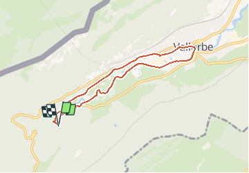
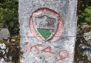
Trail Walking of 6.8 km to be discovered at Vaud, District du Jura-Nord vaudois, Vallorbe. This trail is proposed by vallorbe.

Description

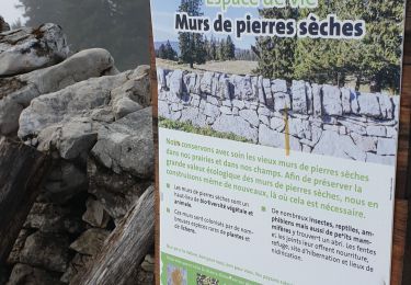
Möglichkeit, das Auto auf dem Parkplatz der Post (weisse Zone, zeitlich unbeschränkt) stehen zu lassen. Start bei der Post, dem Weg der Orbe entlang bis zum Elektrizitätswerk folgen; den Parkplatz der «Grottes» überkehren, den Waldweg Richtung Tropfsteinhöhlen hinaufgehen (Besichtigungsmöglichkeit, Souvenir-Kiosk).
Sobald Sie den Eingang zu den Tropfsteinhöhlen erblicken, bieten sich zwei Möglichkeiten: den Weg bis zur Feengrotte hinaufsteigen, Besichtigung mit Taschenlampe und guter Ausrüstung auf eigene Gefahr; oder auf dem Waldweg bis zur Fischzucht weitergehen (Möglichkeit, Forellen zu fangen).
Rückweg nach Vallorbe ab Café de la Source auf einer Nebenstrasse.

Nach heftigen Regenfällen sollte man nicht am Flussufer gehen, da der Weg dann schlammig und rutschig sein kann.

Elevation profile

Points of interest

Point of interest Vallorbe - Musée du fer - Photo
vallorbe
VALLORBE 
Point of interest Vallorbe - Parking - Photo
vallorbe
VALLORBE 
Point of interest Vallorbe - Usine Electrique - Photo
vallorbe
Point of interest Vallorbe - Grottes - Photo
vallorbe
VALLORBE 

Positioning

Country:
Switzerland
Region :
Vaud
Department/Province :
District du Jura-Nord vaudois
Municipality :
Vallorbe
Location:
Unknown
Start:(UTM)
297077 ; 5175108 (32T) N.

Trails nearby

Trail Mountain bike Vallorbe - Le Suchet - Photo
Mountain bike
GUIDE+

Mountain bike

Very easy
(1)
Vallorbe, Vaud, District du Jura-Nord vaudois, Switzerland
35 km | 53 km-effort
14h 41min
Yes
Trail On foot Vallorbe - Mont d'Orzeires - Le Pont Gare - Photo
On foot
PRO

On foot

Easy
Vallorbe, Vaud, District du Jura-Nord vaudois, Switzerland
3.2 km | 4.4 km-effort
59min
No
Trail On foot L'Abbaye - Pétra Félix-Dent du Vaulion - Photo
On foot
PRO

On foot

Easy
L'Abbaye, Vaud, District du Jura-Nord vaudois, Switzerland
3.1 km | 6.3 km-effort
1h 25min
No
Trail On foot Vallorbe - Saigne Geret-Les Revines - Photo
On foot
PRO

On foot

Easy
Vallorbe, Vaud, District du Jura-Nord vaudois, Switzerland
3.5 km | 4.1 km-effort
56min
No
Trail Walking L'Abbaye - La Dent de Vaulion - Photo
Walking
drarep

Walking

Very difficult
(1)
L'Abbaye, Vaud, District du Jura-Nord vaudois, Switzerland
14.6 km | 22 km-effort
4h 31min
Yes
Trail Walking Rochejean - Mont d'or  - Photo
Walking
eltonnermou

Walking

Easy
Rochejean, Bourgogne-Franche-Comté, Doubs, France
11.9 km | 17.5 km-effort
4h 53min
Yes
Trail Snowshoes L'Abbaye - Le Pont dent de Vaulion Suisse - Photo
Snowshoes
janussity

Snowshoes

Very easy
L'Abbaye, Vaud, District du Jura-Nord vaudois, Switzerland
16.1 km | 24 km-effort
4h 20min
Yes
Trail Mountain bike Longevilles-Mont-d'Or - Mt d Or-Poteau_V2 - Photo
Mountain bike
jeta1

Mountain bike

Easy
Longevilles-Mont-d'Or, Bourgogne-Franche-Comté, Doubs, France
14.7 km | 18.1 km-effort
2h 45min
No
Trail Mountain bike Longevilles-Mont-d'Or - Mt d Or-Poteau - Photo
Mountain bike
jeta1

Mountain bike

Easy
Longevilles-Mont-d'Or, Bourgogne-Franche-Comté, Doubs, France
15.2 km | 18.8 km-effort
2h 45min
No


Close
My subscriptions