


Carla - l’abat - pebelat - vignet - ste Foy Jérusalem

mapomme
User

Length
25 km

Max alt
182 m

Uphill gradient
542 m
Km-Effort
33 km

Min alt
64 m

Downhill gradient
542 m
Boucle
Yes
Creation date :
2019-12-28 09:18:56.0
Updated on :
2019-12-30 11:19:23.281
4h59
Difficulty : Difficult

FREE GPS app for hiking
 SityTrail
IGN / Geographical institutes
SityTrail Plus
The world is yours!
About
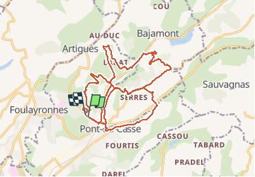
Trail Mountain bike of 25 km to be discovered at New Aquitaine, Lot-et-Garonne, Pont-du-Casse. This trail is proposed by mapomme.
Description
Belle boucle . Ne pas faire attention au temps indiqué j’ai eu qqs pbs mécaniques
Positioning
Country:
France
Region :
New Aquitaine
Department/Province :
Lot-et-Garonne
Municipality :
Pont-du-Casse
Location:
Unknown
Start:(Dec)
Start:(UTM)
314030 ; 4900799 (31T) N.
Comments