Trail Walking Vérignon - chapelles à Verignon 2 01 2020 - Photo

chapelles à Verignon 2 01 2020

 Clodet
Clodet

User

© OpenStreetMap contributors
Length
Length
8.6 km
Max alt
Max alt
1072 m
Uphill gradient
Uphill gradient
341 m
Km-Effort
Km-Effort  
13.1 km
Min alt
Min alt
827 m
Downhill gradient
Downhill gradient
341 m
Boucle
Boucle
Yes
Creation date :
2020-01-02 09:23:56.364
Updated on :
2020-01-02 13:58:55.571

(1 Reviews)

Walking
Walking
4h33
Difficulty : Easy

Scan this QR Code to open this trail in the SityTrail application

FREE GPS app for hiking

Logo SityTrail SityTrail

IGN / Geographical institutes

Download SityTrail from the App Store Download SityTrail from Google Play

Logo SityTrail SityTrail World

The world is yours!

Download SityTrail from the App Store Download SityTrail from Google Play Download SityTrail on Huawei AppGallery

About

Trail Walking of 8.6 km to be discovered at Provence-Alpes-Côte d'Azur, Var, Vérignon. This trail is proposed by Clodet.

Elevation profile

Positioning

Country:
France
Region :
Provence-Alpes-Côte d'Azur
Department/Province :
Var
Municipality :
Vérignon
Location:
Unknown
Start:(UTM)
279576 ; 4837377 (32T) N.

Comments

Please log in to post a review or rate the element


jolie parcours , effectuer avec un enfant de 5 ans en 4 h 30 avec pauses pour manger et goûter


Trails nearby

Trail Walking Vérignon - 2024-01-30 Vérignon - Chapelle Saint Priest - Photo
Walking
GUIDE
Kargil

Walking

Difficult
Vérignon, Provence-Alpes-Côte d'Azur, Var, France
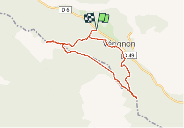
10.5 km | 14.6 km-effort
3h 19min
Yes
Trail Walking Aups - 2023-01-31 Col de la Bigue - Les Eyssariades - Photo
Walking
GUIDE
Kargil

Walking

Medium
Aups, Provence-Alpes-Côte d'Azur, Var, France
16.3 km | 23 km-effort
4h 41min
Yes
Trail Walking Aups - 30-10-2022 Aups Sentier des Crêtes  - Photo
Walking
GUIDE
Kargil

Walking

Medium
Aups, Provence-Alpes-Côte d'Azur, Var, France
20 km | 31 km-effort
5h 0min
Yes
Trail Walking Vérignon - Vérignon - ND Liesse - Moure de Cuiller - Chapelle St Priest - Photo
Walking
LtZIP

Walking

Difficult
Vérignon, Provence-Alpes-Côte d'Azur, Var, France
18 km | 27 km-effort
4h 26min
Yes
Trail Walking Aups - Aups - Grottes - Croix des Pins - Col de Besc - Photo
Walking
LtZIP

Walking

Easy
Aups, Provence-Alpes-Côte d'Azur, Var, France
15.2 km | 21 km-effort
4h 21min
Yes
Trail Walking Aups - AUPS - GROTTES ET CHAPELLES - Photo
Walking
jean-marie.parachini

Walking

Easy
Aups, Provence-Alpes-Côte d'Azur, Var, France
11.6 km | 16.5 km-effort
4h 55min
Yes
Trail Walking Aups - Aups - ND de Liesse - Photo
Walking
ETMU5496

Walking

Medium
Aups, Provence-Alpes-Côte d'Azur, Var, France
21 km | 32 km-effort
4h 54min
Yes
Trail Walking Aups - Aups - Pic de l'aigle - Les Cugulons. - Photo
Walking
Sugg

Walking

Medium
Aups, Provence-Alpes-Côte d'Azur, Var, France
17.3 km | 24 km-effort
5h 8min
Yes
Trail Walking Aups - 2024-01-26 Aups Les 2 Chapelles  - Photo
Walking
GUIDE
Kargil

Walking

Medium
Aups, Provence-Alpes-Côte d'Azur, Var, France
17.4 km | 25 km-effort
5h 43min
Yes


Close
My subscriptions