


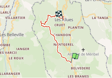
Refuge du Christ depuis Chaudanne

philcll
User

Length
10.4 km

Max alt
1683 m

Uphill gradient
353 m
Km-Effort
16.1 km

Min alt
1105 m

Downhill gradient
673 m
Boucle
No
Creation date :
2020-01-04 09:01:16.854
Updated on :
2020-01-04 18:13:20.098
4h07
Difficulty : Medium

FREE GPS app for hiking
 SityTrail
IGN / Geographical institutes
SityTrail Plus
The world is yours!
About
Trail Walking of 10.4 km to be discovered at Auvergne-Rhône-Alpes, Savoy, Les Allues. This trail is proposed by philcll.
Description
de Chaudanne à la Traye (refuge du Christ), retour par les Allues
Photos

Positioning
Country:
France
Region :
Auvergne-Rhône-Alpes
Department/Province :
Savoy
Municipality :
Les Allues
Location:
Unknown
Start:(Dec)
Start:(UTM)
309383 ; 5029961 (32T) N.
Comments