


2020.01.09.Landser

ROPPJP
User
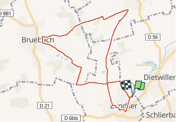

Length
10 km

Max alt
341 m

Uphill gradient
170 m
Km-Effort
12.3 km

Min alt
250 m

Downhill gradient
171 m
Boucle
Yes
Creation date :
2020-01-09 12:24:52.151
Updated on :
2020-01-09 15:19:36.857
2h53
Difficulty : Very easy

FREE GPS app for hiking
 SityTrail
IGN / Geographical institutes
SityTrail Plus
The world is yours!
About
Trail Walking of 10 km to be discovered at Grand Est, Haut-Rhin, Landser. This trail is proposed by ROPPJP.
Positioning
Country:
France
Region :
Grand Est
Department/Province :
Haut-Rhin
Municipality :
Landser
Location:
Unknown
Start:(Dec)
Start:(UTM)
379494 ; 5282782 (32T) N.
Comments