


St amarin-Abri Wueste (des chasseurs)

JCLUTT
User
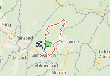

Length
10.7 km

Max alt
875 m

Uphill gradient
539 m
Km-Effort
17.9 km

Min alt
420 m

Downhill gradient
539 m
Boucle
Yes
Creation date :
2020-01-09 08:17:04.0
Updated on :
2021-05-25 11:23:11.611
4h42
Difficulty : Difficult

FREE GPS app for hiking
 SityTrail
IGN / Geographical institutes
SityTrail Plus
The world is yours!
About
Trail Walking of 10.7 km to be discovered at Grand Est, Haut-Rhin, Saint-Amarin. This trail is proposed by JCLUTT.
Description
Belle randonnée sportive par un temps exceptionnel pour la saison !
Positioning
Country:
France
Region :
Grand Est
Department/Province :
Haut-Rhin
Municipality :
Saint-Amarin
Location:
Unknown
Start:(Dec)
Start:(UTM)
352875 ; 5304378 (32T) N.
Comments