


Bellemagny Sonia Jacques

gerando
User
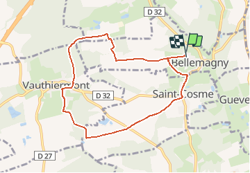

Length
8.3 km

Max alt
419 m

Uphill gradient
118 m
Km-Effort
9.8 km

Min alt
341 m

Downhill gradient
120 m
Boucle
Yes
Creation date :
2020-01-09 18:46:49.81
Updated on :
2020-01-09 18:47:48.906
2h08
Difficulty : Medium

FREE GPS app for hiking
 SityTrail
IGN / Geographical institutes
SityTrail Plus
The world is yours!
About
Trail Walking of 8.3 km to be discovered at Grand Est, Haut-Rhin, Bellemagny. This trail is proposed by gerando.
Positioning
Country:
France
Region :
Grand Est
Department/Province :
Haut-Rhin
Municipality :
Bellemagny
Location:
Unknown
Start:(Dec)
Start:(UTM)
354674 ; 5283666 (32T) N.
Comments