


Saint Laurent de Cerdans Puig de La Senyoral

patbt
User
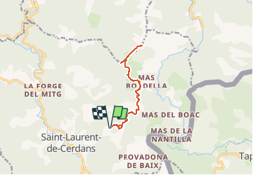

Length
12.5 km

Max alt
1304 m

Uphill gradient
534 m
Km-Effort
19.6 km

Min alt
805 m

Downhill gradient
534 m
Boucle
Yes
Creation date :
2020-01-12 10:58:07.292
Updated on :
2020-01-13 08:02:34.312
5h34
Difficulty : Easy

FREE GPS app for hiking
 SityTrail
IGN / Geographical institutes
SityTrail Plus
The world is yours!
About
Trail Walking of 12.5 km to be discovered at Occitania, Pyrénées-Orientales, Saint-Laurent-de-Cerdans. This trail is proposed by patbt.
Positioning
Country:
France
Region :
Occitania
Department/Province :
Pyrénées-Orientales
Municipality :
Saint-Laurent-de-Cerdans
Location:
Unknown
Start:(Dec)
Start:(UTM)
469782 ; 4693186 (31T) N.
Comments