


Cahors-Montcuq

ghislainem
User
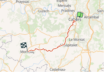

Length
32 km

Max alt
305 m

Uphill gradient
640 m
Km-Effort
40 km

Min alt
110 m

Downhill gradient
560 m
Boucle
No
Creation date :
2020-01-17 17:12:54.609
Updated on :
2020-08-09 07:06:55.867
--
Difficulty : Unknown

FREE GPS app for hiking
 SityTrail
IGN / Geographical institutes
SityTrail Plus
The world is yours!
About
Trail On foot of 32 km to be discovered at Occitania, Lot, Cahors. This trail is proposed by ghislainem.
Positioning
Country:
France
Region :
Occitania
Department/Province :
Lot
Municipality :
Cahors
Location:
Unknown
Start:(Dec)
Start:(UTM)
376042 ; 4922245 (31T) N.
Comments