Trail Walking Bézaudun-les-Alpes - Bezaudun L'Estellier - Photo
 GrouGary
GrouGary

User

© OpenStreetMap contributors
Length
Length
16 km
Max alt
Max alt
1267 m
Uphill gradient
Uphill gradient
828 m
Km-Effort
Km-Effort  
27 km
Min alt
Min alt
669 m
Downhill gradient
Downhill gradient
825 m
Boucle
Boucle
Yes
Creation date :
2020-01-19 07:52:03.59
Updated on :
2020-02-08 09:58:56.527

(0 Reviews)

Walking
Walking
6h47
Difficulty : Medium

Scan this QR Code to open this trail in the SityTrail application

FREE GPS app for hiking

Logo SityTrail SityTrail

IGN / Geographical institutes

Download SityTrail from the App Store Download SityTrail from Google Play

Logo SityTrail SityTrail World

The world is yours!

Download SityTrail from the App Store Download SityTrail from Google Play Download SityTrail on Huawei AppGallery

About

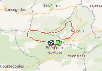
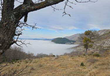
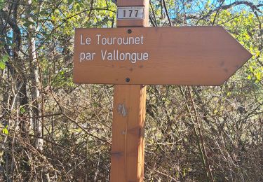
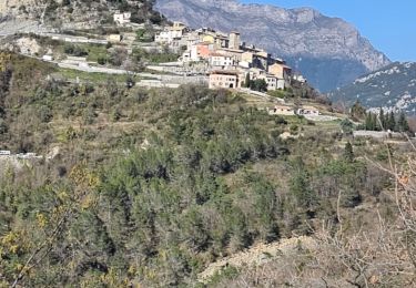
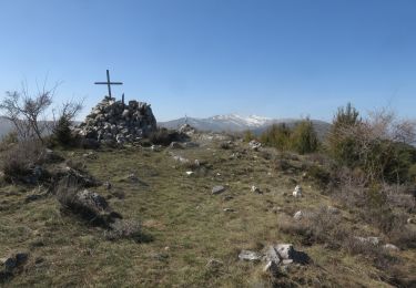
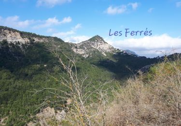
Trail Walking of 16 km to be discovered at Provence-Alpes-Côte d'Azur, Maritime Alps, Bézaudun-les-Alpes. This trail is proposed by GrouGary.

Description

Boucle dans les anciennes zones pastorales, borries... Pause repas compris et enregistrée

Elevation profile

Photos

Positioning

Country:
France
Region :
Provence-Alpes-Côte d'Azur
Department/Province :
Maritime Alps
Municipality :
Bézaudun-les-Alpes
Location:
Unknown
Start:(UTM)
346885 ; 4852400 (32T) N.

Trails nearby

Trail On foot Bouyon - track - Photo
On foot
domi06

On foot

Medium
(1)
Bouyon, Provence-Alpes-Côte d'Azur, Maritime Alps, France
16 km | 29 km-effort
6h 0min
Yes
Trail On foot Coursegoules - Circuit du Viériou - Photo
On foot
PRO

On foot

Easy
Coursegoules, Provence-Alpes-Côte d'Azur, Maritime Alps, France
7.5 km | 13.1 km-effort
2h 58min
Yes
Trail On foot Bouyon - Gorges de l'Estéron - Photo
On foot
PRO

On foot

Medium
Bouyon, Provence-Alpes-Côte d'Azur, Maritime Alps, France
12 km | 22 km-effort
5h 3min
Yes
Trail Running Coursegoules - 2 ème et 3 ème relais cipieres  - Photo
Running
guess

Running

Difficult
(1)
Coursegoules, Provence-Alpes-Côte d'Azur, Maritime Alps, France
36 km | 59 km-effort
7h 13min
No
Trail Walking Coursegoules - Coursegoule, Sommets Vierou et Prêt  - Photo
Walking
GrouGary

Walking

Very easy
Coursegoules, Provence-Alpes-Côte d'Azur, Maritime Alps, France
12.2 km | 19.5 km-effort
5h 53min
Yes
Trail Walking Coursegoules - Circuit de Vallon - Photo
Walking
56jj

Walking

Medium
(1)
Coursegoules, Provence-Alpes-Côte d'Azur, Maritime Alps, France
10.5 km | 14.8 km-effort
3h 29min
Yes
Trail Walking Les Ferres - les ferres consegudes  - Photo
Walking
Mariephil

Walking

Very difficult
Les Ferres, Provence-Alpes-Côte d'Azur, Maritime Alps, France
11.8 km | 19.6 km-effort
4h 45min
Yes
Trail Walking Bézaudun-les-Alpes - Mont Estellier au départ de Bézaudun - Photo
Walking
aris

Walking

Medium
Bézaudun-les-Alpes, Provence-Alpes-Côte d'Azur, Maritime Alps, France
13.4 km | 21 km-effort
5h 40min
Yes
Trail Walking Les Ferres - Les Ferres Conségudes et rive droite Esteron - Photo
Walking
GrouGary

Walking

Medium
Les Ferres, Provence-Alpes-Côte d'Azur, Maritime Alps, France
13.4 km | 23 km-effort
8h 50min
Yes


Close
My subscriptions