


Dordogne : Vitrac/St Cyprien

mhetpierre
User
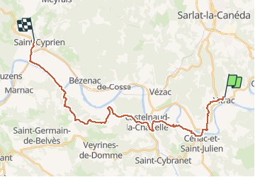

Length
28 km

Max alt
224 m

Uphill gradient
613 m
Km-Effort
37 km

Min alt
58 m

Downhill gradient
658 m
Boucle
No
Creation date :
2020-01-22 16:56:16.11
Updated on :
2020-01-22 16:57:58.982
--
Difficulty : Very easy

FREE GPS app for hiking
 SityTrail
IGN / Geographical institutes
SityTrail Plus
The world is yours!
About
Trail On foot of 28 km to be discovered at New Aquitaine, Dordogne, Vitrac. This trail is proposed by mhetpierre.
Positioning
Country:
France
Region :
New Aquitaine
Department/Province :
Dordogne
Municipality :
Vitrac
Location:
Unknown
Start:(Dec)
Start:(UTM)
359783 ; 4965670 (31T) N.
Comments