


ski

xav34830
User
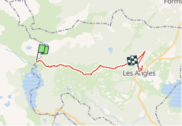

Length
9.9 km

Max alt
2363 m

Uphill gradient
328 m
Km-Effort
15.6 km

Min alt
1661 m

Downhill gradient
716 m
Boucle
No
Creation date :
2020-01-25 13:17:13.509
Updated on :
2020-01-25 16:48:45.034
3h25
Difficulty : Very easy

FREE GPS app for hiking
 SityTrail
IGN / Geographical institutes
SityTrail Plus
The world is yours!
About
Trail Touring skiing of 9.9 km to be discovered at Occitania, Pyrénées-Orientales, Angoustrine-Villeneuve-des-Escaldes. This trail is proposed by xav34830.
Positioning
Country:
France
Region :
Occitania
Department/Province :
Pyrénées-Orientales
Municipality :
Angoustrine-Villeneuve-des-Escaldes
Location:
Unknown
Start:(Dec)
Start:(UTM)
418184 ; 4715106 (31T) N.
Comments