


Mont Saint Cyr

PascalBanide
User
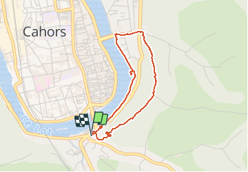

Length
3.5 km

Max alt
264 m

Uphill gradient
152 m
Km-Effort
5.5 km

Min alt
114 m

Downhill gradient
150 m
Boucle
Yes
Creation date :
2020-01-26 14:11:12.0
Updated on :
2020-01-26 15:40:29.979
1h27
Difficulty : Very difficult

FREE GPS app for hiking
 SityTrail
IGN / Geographical institutes
SityTrail Plus
The world is yours!
About
Trail Walking of 3.5 km to be discovered at Occitania, Lot, Cahors. This trail is proposed by PascalBanide.
Positioning
Country:
France
Region :
Occitania
Department/Province :
Lot
Municipality :
Cahors
Location:
Unknown
Start:(Dec)
Start:(UTM)
376049 ; 4921964 (31T) N.
Comments