


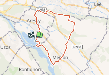
Tracé

mitch1952
User

Length
8.4 km

Max alt
251 m

Uphill gradient
76 m
Km-Effort
9.4 km

Min alt
186 m

Downhill gradient
75 m
Boucle
Yes
Creation date :
2020-01-28 16:16:10.211
Updated on :
2022-06-01 19:33:14.733
2h08
Difficulty : Medium

FREE GPS app for hiking
 SityTrail
IGN / Geographical institutes
SityTrail Plus
The world is yours!
About
Trail Walking of 8.4 km to be discovered at New Aquitaine, Pyrénées-Atlantiques, Aressy. This trail is proposed by mitch1952.


Positioning
Country:
France
Region :
New Aquitaine
Department/Province :
Pyrénées-Atlantiques
Municipality :
Aressy
Location:
Unknown
Start:(Dec)
Start:(UTM)
716931 ; 4794518 (30T) N.
Comments