


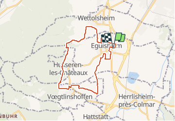
2020 02 Expert dénivelé Eguisheim

staubalex
User

Length
14.6 km

Max alt
438 m

Uphill gradient
335 m
Km-Effort
19 km

Min alt
193 m

Downhill gradient
335 m
Boucle
Yes
Creation date :
2020-02-01 07:12:38.312
Updated on :
2020-02-01 07:27:24.369
1h14
Difficulty : Easy
--
Difficulty : Difficult

FREE GPS app for hiking
 SityTrail
IGN / Geographical institutes
SityTrail Plus
The world is yours!
About
Trail Mountain bike of 14.6 km to be discovered at Grand Est, Haut-Rhin, Eguisheim. This trail is proposed by staubalex.
Positioning
Country:
France
Region :
Grand Est
Department/Province :
Haut-Rhin
Municipality :
Eguisheim
Location:
Unknown
Start:(Dec)
Start:(UTM)
374242 ; 5322498 (32U) N.
Comments