Trail Walking Gemeinde Au - Alpgang - Photo
 michelek
michelek

User

© OpenStreetMap contributors
Length
Length
9.4 km
Max alt
Max alt
1495 m
Uphill gradient
Uphill gradient
681 m
Km-Effort
Km-Effort  
18.5 km
Min alt
Min alt
827 m
Downhill gradient
Downhill gradient
685 m
Boucle
Boucle
Yes
Creation date :
2018-11-10 10:10:13.113
Updated on :
2018-11-10 10:10:13.619

(0 Reviews)

Walking
Walking
3h42
Difficulty : Medium

Scan this QR Code to open this trail in the SityTrail application

FREE GPS app for hiking

Logo SityTrail SityTrail

IGN / Geographical institutes

Download SityTrail from the App Store Download SityTrail from Google Play

Logo SityTrail SityTrail World

The world is yours!

Download SityTrail from the App Store Download SityTrail from Google Play Download SityTrail on Huawei AppGallery

About

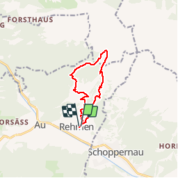
Trail Walking of 9.4 km to be discovered at Vorarlberg, Bezirk Bregenz, Gemeinde Au. This trail is proposed by michelek.

Description

Randonnée faisant le tour des alpages de Au - Schopernau.
Assez pentu au démarrage
Site web:http://www.bregenzerwald.at/s/en/au-schoppernau-alpgang

Elevation profile

Positioning

Country:
Austria
Region :
Vorarlberg
Department/Province :
Bezirk Bregenz
Municipality :
Gemeinde Au
Location:
Unknown
Start:(UTM)
575405 ; 5241435 (32T) N.

Trails nearby

Trail Snowshoes Gemeinde Schoppernau - Autriche - Schoppernau - Toblermann  - Photo
Snowshoes
michel.heusschen@skynet.be

Snowshoes

Very easy
Gemeinde Schoppernau, Vorarlberg, Bezirk Bregenz, Austria
5.9 km | 16.4 km-effort
4h 0min
No


Close
My subscriptions