


Buhl munteraeckerle hugstein

pascalloos
User
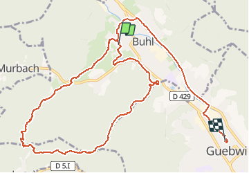

Length
13 km

Max alt
665 m

Uphill gradient
379 m
Km-Effort
18.3 km

Min alt
299 m

Downhill gradient
439 m
Boucle
No
Creation date :
2020-02-04 12:27:49.736
Updated on :
2020-02-04 16:31:12.523
4h01
Difficulty : Easy

FREE GPS app for hiking
 SityTrail
IGN / Geographical institutes
SityTrail Plus
The world is yours!
About
Trail Walking of 13 km to be discovered at Grand Est, Haut-Rhin, Buhl. This trail is proposed by pascalloos.
Positioning
Country:
France
Region :
Grand Est
Department/Province :
Haut-Rhin
Municipality :
Buhl
Location:
Unknown
Start:(Dec)
Start:(UTM)
364226 ; 5309804 (32T) N.
Comments