


WILLER-Chap.ST NICOLAS-Ferme d'OSTEIN

patrickbeyrath
User
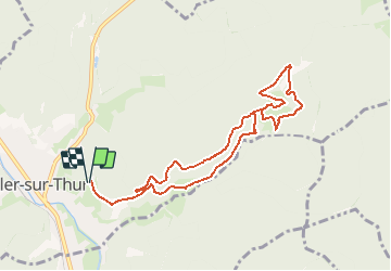

Length
8.9 km

Max alt
712 m

Uphill gradient
392 m
Km-Effort
14.2 km

Min alt
400 m

Downhill gradient
393 m
Boucle
Yes
Creation date :
2018-10-13 05:53:14.226
Updated on :
2018-10-13 05:53:14.25
3h07
Difficulty : Medium

FREE GPS app for hiking
 SityTrail
IGN / Geographical institutes
SityTrail Plus
The world is yours!
About
Trail Walking of 8.9 km to be discovered at Grand Est, Haut-Rhin, Willer-sur-Thur. This trail is proposed by patrickbeyrath.
Positioning
Country:
France
Region :
Grand Est
Department/Province :
Haut-Rhin
Municipality :
Willer-sur-Thur
Location:
Unknown
Start:(Dec)
Start:(UTM)
356337 ; 5300735 (32T) N.
Comments