


limendous Rs fait

LouisROGER
User GUIDE
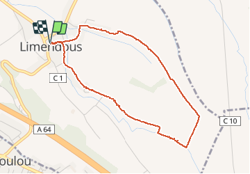

Length
4.5 km

Max alt
380 m

Uphill gradient
28 m
Km-Effort
4.9 km

Min alt
363 m

Downhill gradient
28 m
Boucle
Yes
Creation date :
2020-02-11 12:55:01.947
Updated on :
2020-02-11 14:25:46.486
1h29
Difficulty : Very easy

FREE GPS app for hiking
 SityTrail
IGN / Geographical institutes
SityTrail Plus
The world is yours!
About
Trail Walking of 4.5 km to be discovered at New Aquitaine, Pyrénées-Atlantiques, Limendous. This trail is proposed by LouisROGER.
Positioning
Country:
France
Region :
New Aquitaine
Department/Province :
Pyrénées-Atlantiques
Municipality :
Limendous
Location:
Unknown
Start:(Dec)
Start:(UTM)
728659 ; 4795347 (30T) N.
Comments