


Ferme des Olivettes

frizou83
User
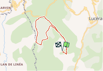

Length
7.7 km

Max alt
966 m

Uphill gradient
382 m
Km-Effort
12.8 km

Min alt
626 m

Downhill gradient
382 m
Boucle
Yes
Creation date :
2020-02-19 15:57:59.995
Updated on :
2020-02-19 15:58:42.789
2h37
Difficulty : Medium

FREE GPS app for hiking
 SityTrail
IGN / Geographical institutes
SityTrail Plus
The world is yours!
About
Trail Walking of 7.7 km to be discovered at Provence-Alpes-Côte d'Azur, Maritime Alps, Lucéram. This trail is proposed by frizou83.
Positioning
Country:
France
Region :
Provence-Alpes-Côte d'Azur
Department/Province :
Maritime Alps
Municipality :
Lucéram
Location:
Unknown
Start:(Dec)
Start:(UTM)
366597 ; 4858821 (32T) N.
Comments