


monho haltzamendi 1

FERREREMARC
User
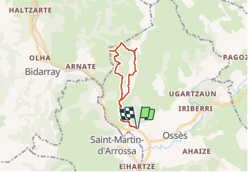

Length
11.8 km

Max alt
794 m

Uphill gradient
762 m
Km-Effort
22 km

Min alt
128 m

Downhill gradient
761 m
Boucle
Yes
Creation date :
2020-02-20 08:28:06.164
Updated on :
2020-02-20 14:40:24.024
6h11
Difficulty : Very easy

FREE GPS app for hiking
 SityTrail
IGN / Geographical institutes
SityTrail Plus
The world is yours!
About
Trail Walking of 11.8 km to be discovered at New Aquitaine, Pyrénées-Atlantiques, Ossès. This trail is proposed by FERREREMARC.
Positioning
Country:
France
Region :
New Aquitaine
Department/Province :
Pyrénées-Atlantiques
Municipality :
Ossès
Location:
Unknown
Start:(Dec)
Start:(UTM)
637817 ; 4789355 (30T) N.
Comments