


Okilarré depuis Monho

FERREREMARC
User
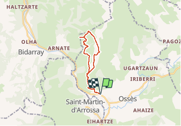

Length
11 km

Max alt
709 m

Uphill gradient
670 m
Km-Effort
19.9 km

Min alt
128 m

Downhill gradient
669 m
Boucle
Yes
Creation date :
2020-02-20 08:25:17.246
Updated on :
2020-02-20 14:44:19.372
4h47
Difficulty : Very easy

FREE GPS app for hiking
 SityTrail
IGN / Geographical institutes
SityTrail Plus
The world is yours!
About
Trail Walking of 11 km to be discovered at New Aquitaine, Pyrénées-Atlantiques, Ossès. This trail is proposed by FERREREMARC.
Positioning
Country:
France
Region :
New Aquitaine
Department/Province :
Pyrénées-Atlantiques
Municipality :
Ossès
Location:
Unknown
Start:(Dec)
Start:(UTM)
637817 ; 4789357 (30T) N.
Comments