


Sommières

ARVIEU
User
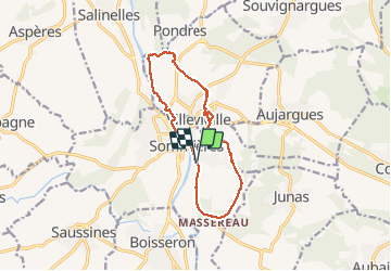

Length
13.1 km

Max alt
102 m

Uphill gradient
137 m
Km-Effort
14.9 km

Min alt
24 m

Downhill gradient
134 m
Boucle
Yes
Creation date :
2020-02-21 07:07:02.239
Updated on :
2020-02-21 10:25:05.126
3h16
Difficulty : Easy

FREE GPS app for hiking
 SityTrail
IGN / Geographical institutes
SityTrail Plus
The world is yours!
About
Trail Walking of 13.1 km to be discovered at Occitania, Gard, Sommières. This trail is proposed by ARVIEU.
Photos


Positioning
Country:
France
Region :
Occitania
Department/Province :
Gard
Municipality :
Sommières
Location:
Unknown
Start:(Dec)
Start:(UTM)
587948 ; 4847865 (31T) N.
Comments