


Col Fouchy - Frankenbourg - Chalmont

RUHLMANN
User
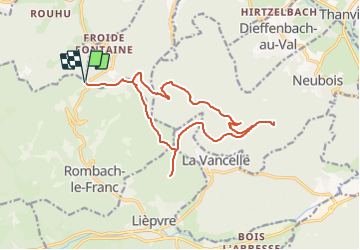

Length
16.7 km

Max alt
860 m

Uphill gradient
649 m
Km-Effort
25 km

Min alt
606 m

Downhill gradient
649 m
Boucle
Yes
Creation date :
2020-02-21 17:03:26.718
Updated on :
2022-03-04 09:28:51.192
--
Difficulty : Medium

FREE GPS app for hiking
 SityTrail
IGN / Geographical institutes
SityTrail Plus
The world is yours!
About
Trail On foot of 16.7 km to be discovered at Grand Est, Haut-Rhin, Rombach-le-Franc. This trail is proposed by RUHLMANN.
Positioning
Country:
France
Region :
Grand Est
Department/Province :
Haut-Rhin
Municipality :
Rombach-le-Franc
Location:
Unknown
Start:(Dec)
Start:(UTM)
370959 ; 5351632 (32U) N.
Comments