


Crete de cote longue par le col de Claret

claude nier
User
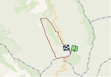

Length
4.9 km

Max alt
1321 m

Uphill gradient
306 m
Km-Effort
9 km

Min alt
1006 m

Downhill gradient
309 m
Boucle
Yes
Creation date :
2020-02-21 18:53:30.251
Updated on :
2020-02-21 18:55:04.545
--
Difficulty : Easy

FREE GPS app for hiking
 SityTrail
IGN / Geographical institutes
SityTrail Plus
The world is yours!
About
Trail On foot of 4.9 km to be discovered at Auvergne-Rhône-Alpes, Isère, Chichilianne. This trail is proposed by claude nier.
Description
petite rando sympa
Positioning
Country:
France
Region :
Auvergne-Rhône-Alpes
Department/Province :
Isère
Municipality :
Chichilianne
Location:
Unknown
Start:(Dec)
Start:(UTM)
705574 ; 4962400 (31T) N.
Comments