


Sorède La Farga - Roc de les Medes - Castel d'Ultrera

patbt
User
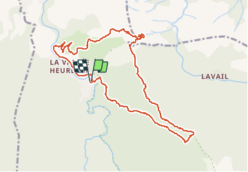

Length
11.7 km

Max alt
675 m

Uphill gradient
604 m
Km-Effort
19.8 km

Min alt
159 m

Downhill gradient
609 m
Boucle
Yes
Creation date :
2020-02-22 11:38:02.662
Updated on :
2020-02-22 16:57:35.523
5h07
Difficulty : Easy

FREE GPS app for hiking
 SityTrail
IGN / Geographical institutes
SityTrail Plus
The world is yours!
About
Trail Walking of 11.7 km to be discovered at Occitania, Pyrénées-Orientales, Sorède. This trail is proposed by patbt.
Positioning
Country:
France
Region :
Occitania
Department/Province :
Pyrénées-Orientales
Municipality :
Sorède
Location:
Unknown
Start:(Dec)
Start:(UTM)
497286 ; 4706079 (31T) N.
Comments