


Col de Chaleby

mpignon
User
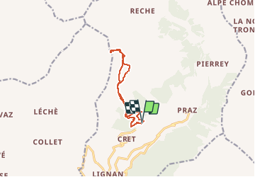

Length
9.7 km

Max alt
2682 m

Uphill gradient
741 m
Km-Effort
19.6 km

Min alt
1952 m

Downhill gradient
737 m
Boucle
Yes
Creation date :
2020-02-24 07:45:10.692
Updated on :
2020-02-25 08:08:57.45
3h24
Difficulty : Easy

FREE GPS app for hiking
 SityTrail
IGN / Geographical institutes
SityTrail Plus
The world is yours!
About
Trail Touring skiing of 9.7 km to be discovered at Aosta Valley, Unknown, Nus. This trail is proposed by mpignon.
Positioning
Country:
Italy
Region :
Aosta Valley
Department/Province :
Unknown
Municipality :
Nus
Location:
Unknown
Start:(Dec)
Start:(UTM)
383120 ; 5073379 (32T) N.
Comments