


ST3 rando Ger

LouisROGER
User GUIDE
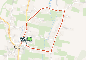

Length
2.1 km

Max alt
407 m

Uphill gradient
12 m
Km-Effort
2.3 km

Min alt
395 m

Downhill gradient
12 m
Boucle
Yes
Creation date :
2020-02-27 08:58:40.223
Updated on :
2020-02-27 10:21:26.045
--
Difficulty : Very easy

FREE GPS app for hiking
 SityTrail
IGN / Geographical institutes
SityTrail Plus
The world is yours!
About
Trail On foot of 2.1 km to be discovered at New Aquitaine, Pyrénées-Atlantiques, Ger. This trail is proposed by LouisROGER.

Positioning
Country:
France
Region :
New Aquitaine
Department/Province :
Pyrénées-Atlantiques
Municipality :
Ger
Location:
Unknown
Start:(Dec)
Start:(UTM)
739382 ; 4793117 (30T) N.
Comments