


Vauvenargues - Encuminière

mhetpierre
User
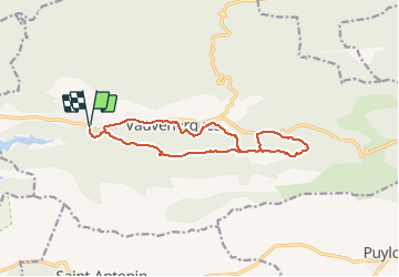

Length
14.4 km

Max alt
585 m

Uphill gradient
431 m
Km-Effort
20 km

Min alt
348 m

Downhill gradient
431 m
Boucle
Yes
Creation date :
2020-02-27 09:06:43.769
Updated on :
2020-02-27 16:09:01.592
--
Difficulty : Very easy

FREE GPS app for hiking
 SityTrail
IGN / Geographical institutes
SityTrail Plus
The world is yours!
About
Trail On foot of 14.4 km to be discovered at Provence-Alpes-Côte d'Azur, Bouches-du-Rhône, Vauvenargues. This trail is proposed by mhetpierre.
Positioning
Country:
France
Region :
Provence-Alpes-Côte d'Azur
Department/Province :
Bouches-du-Rhône
Municipality :
Vauvenargues
Location:
Unknown
Start:(Dec)
Start:(UTM)
708302 ; 4825580 (31T) N.
Comments