


ful

bubu90
User
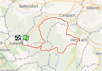

Length
18.4 km

Max alt
414 m

Uphill gradient
282 m
Km-Effort
22 km

Min alt
299 m

Downhill gradient
282 m
Boucle
Yes
Creation date :
2020-02-28 08:34:38.164
Updated on :
2020-02-29 07:10:46.369
4h51
Difficulty : Very easy

FREE GPS app for hiking
 SityTrail
IGN / Geographical institutes
SityTrail Plus
The world is yours!
About
Trail Walking of 18.4 km to be discovered at Grand Est, Haut-Rhin, Fulleren. This trail is proposed by bubu90.
Positioning
Country:
France
Region :
Grand Est
Department/Province :
Haut-Rhin
Municipality :
Fulleren
Location:
Unknown
Start:(Dec)
Start:(UTM)
361215 ; 5272845 (32T) N.
Comments