


2020 03 07 Cross Firsplan Exa Difficile

staubalex
User
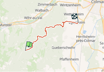

Length
17.7 km

Max alt
891 m

Uphill gradient
371 m
Km-Effort
24 km

Min alt
196 m

Downhill gradient
898 m
Boucle
No
Creation date :
2020-03-07 08:08:03.558
Updated on :
2020-03-07 08:27:27.676
1h10
Difficulty : Easy

FREE GPS app for hiking
 SityTrail
IGN / Geographical institutes
SityTrail Plus
The world is yours!
About
Trail Mountain bike of 17.7 km to be discovered at Grand Est, Haut-Rhin, Soultzmatt. This trail is proposed by staubalex.
Positioning
Country:
France
Region :
Grand Est
Department/Province :
Haut-Rhin
Municipality :
Soultzmatt
Location:
Unknown
Start:(Dec)
Start:(UTM)
364611 ; 5317805 (32T) N.
Comments