


11070214-Rando 46 km 2020 R&B

mico40
User
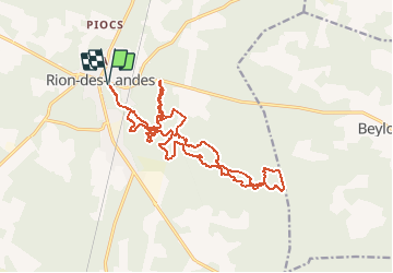

Length
21 km

Max alt
86 m

Uphill gradient
210 m
Km-Effort
24 km

Min alt
50 m

Downhill gradient
210 m
Boucle
Yes
Creation date :
2020-03-11 12:20:26.596
Updated on :
2020-06-22 10:19:03.158
--
Difficulty : Very easy

FREE GPS app for hiking
 SityTrail
IGN / Geographical institutes
SityTrail Plus
The world is yours!
About
Trail Trail of 21 km to be discovered at New Aquitaine, Landes, Rion-des-Landes. This trail is proposed by mico40.
Positioning
Country:
France
Region :
New Aquitaine
Department/Province :
Landes
Municipality :
Rion-des-Landes
Location:
Rion-des-Landes
Start:(Dec)
Start:(UTM)
667006 ; 4866542 (30T) N.
Comments