Trail Walking Mandelieu-la-Napoule - de Mandelieu à Boulouris - Photo
 ETMU5496
ETMU5496

User

© OpenStreetMap contributors
Length
Length
29 km
Max alt
Max alt
429 m
Uphill gradient
Uphill gradient
1119 m
Km-Effort
Km-Effort  
43 km
Min alt
Min alt
4 m
Downhill gradient
Downhill gradient
1121 m
Boucle
Boucle
No
Creation date :
2020-03-11 07:55:44.0
Updated on :
2020-03-22 18:25:40.464

(0 Reviews)

Walking
Walking
6h53
Difficulty : Difficult

Scan this QR Code to open this trail in the SityTrail application

FREE GPS app for hiking

Logo SityTrail SityTrail

IGN / Geographical institutes

Download SityTrail from the App Store Download SityTrail from Google Play

Logo SityTrail SityTrail World

The world is yours!

Download SityTrail from the App Store Download SityTrail from Google Play Download SityTrail on Huawei AppGallery

About

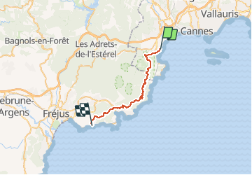
Trail Walking of 29 km to be discovered at Provence-Alpes-Côte d'Azur, Maritime Alps, Mandelieu-la-Napoule. This trail is proposed by ETMU5496.

Description

Jolie traversée de l'Esterel sur sa partie la plus proche du littoral.
Pas de difficulté majeure hormis la longueur du parcours

Elevation profile

Photos

Positioning

Country:
France
Region :
Provence-Alpes-Côte d'Azur
Department/Province :
Maritime Alps
Municipality :
Mandelieu-la-Napoule
Location:
Unknown
Start:(UTM)
333633 ; 4821079 (32T) N.

Trails nearby

Trail Walking Mandelieu-la-Napoule - Mont Saint Martin - Photo
Walking
Kilroy06

Walking

Easy
(1)
Mandelieu-la-Napoule, Provence-Alpes-Côte d'Azur, Maritime Alps, France
9 km | 14.2 km-effort
3h 0min
Yes
Trail On foot Théoule-sur-Mer - Tracé Rocher des Monges par col de Théoule - Photo
On foot
Sylvie Cagnes

On foot

Very easy
(1)
Théoule-sur-Mer, Provence-Alpes-Côte d'Azur, Maritime Alps, France
7.2 km | 11.2 km-effort
Unknown
Yes
Trail Walking Mandelieu-la-Napoule - Grand Duc Alternatif - Photo
Walking
exxonz

Walking

Very easy
(1)
Mandelieu-la-Napoule, Provence-Alpes-Côte d'Azur, Maritime Alps, France
6.4 km | 9.1 km-effort
2h 0min
Yes
Trail Walking Théoule-sur-Mer - Théoule - Col de Théoule - ND d'Afrique - Pointe de L'Aiguille - Photo
Walking
LtZIP

Walking

Easy
Théoule-sur-Mer, Provence-Alpes-Côte d'Azur, Maritime Alps, France
9.9 km | 14.9 km-effort
3h 23min
Yes
Trail Walking Saint-Raphaël - PK ND Theoule - Photo
Walking
ETMU5496

Walking

Difficult
Saint-Raphaël, Provence-Alpes-Côte d'Azur, Var, France
18.5 km | 30 km-effort
6h 47min
Yes
Trail sport Mandelieu-la-Napoule - Forêt du Grand Duc - Tanneron - Photo
sport
000837.d1413b0437e14c51ba1cc22669f70606.1648

sport

Very easy
Mandelieu-la-Napoule, Provence-Alpes-Côte d'Azur, Maritime Alps, France
8.4 km | 12.1 km-effort
Unknown
Yes
Trail Walking Mandelieu-la-Napoule - Mandelieu - Chapelle St Jean - Baisse Violette - Suvières - Marsaou - Col des 3 Termes - Oeufs de Bouc - Photo
Walking
LtZIP

Walking

Medium
Mandelieu-la-Napoule, Provence-Alpes-Côte d'Azur, Maritime Alps, France
16.3 km | 25 km-effort
5h 0min
Yes
Trail Walking Théoule-sur-Mer - Notre dame d'Afrique  - Photo
Walking
56jj

Walking

Easy
Théoule-sur-Mer, Provence-Alpes-Côte d'Azur, Maritime Alps, France
8 km | 11.4 km-effort
2h 27min
Yes
Trail Walking Mandelieu-la-Napoule - Grotte des œufs de bouc  - Photo
Walking
ETMU5496

Walking

Medium
Mandelieu-la-Napoule, Provence-Alpes-Côte d'Azur, Maritime Alps, France
19.3 km | 31 km-effort
4h 54min
Yes


Close
My subscriptions