Trail On foot Saint-Gilles-de-Crétot - Saint Gilles de Crétot - Photo
© OpenStreetMap contributors
Length
Length
6.1 km
Max alt
Max alt
143 m
Uphill gradient
Uphill gradient
101 m
Km-Effort
Km-Effort  
7.5 km
Min alt
Min alt
60 m
Downhill gradient
Downhill gradient
102 m
Boucle
Boucle
Yes
Creation date :
2020-03-14 17:01:10.817
Updated on :
2020-03-14 17:03:44.476

(0 Reviews)

On foot
On foot
1h30
Difficulty : Easy

Scan this QR Code to open this trail in the SityTrail application

FREE GPS app for hiking

Logo SityTrail SityTrail

IGN / Geographical institutes

Download SityTrail from the App Store Download SityTrail from Google Play

Logo SityTrail SityTrail World

The world is yours!

Download SityTrail from the App Store Download SityTrail from Google Play Download SityTrail on Huawei AppGallery

About

Trail On foot of 6.1 km to be discovered at Normandy, Seine-Maritime, Saint-Gilles-de-Crétot. This trail is proposed by JMCMoreau.

Description

Promenade digestive. Très bien pour un dimanche après-midi.

Elevation profile

Positioning

Country:
France
Region :
Normandy
Department/Province :
Seine-Maritime
Municipality :
Saint-Gilles-de-Crétot
Location:
Unknown
Start:(UTM)
329558 ; 5492037 (31U) N.

Trails nearby

Trail Walking Rives-en-Seine - Balade à Villequier - Photo
Walking
tracegps

Walking

Easy
(1)
Rives-en-Seine, Normandy, Seine-Maritime, France
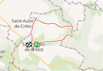
9.7 km | 12.5 km-effort
2h 0min
Yes
Trail Walking Allouville-Bellefosse - allouille bellefosse - Photo
Walking
jmp76700

Walking

Very easy
(2)
Allouville-Bellefosse, Normandy, Seine-Maritime, France
10.4 km | 12.6 km-effort
2h 30min
Yes
Trail Walking Allouville-Bellefosse - Allouville -Bellefosse - Photo
Walking
MichelRando7656

Walking

Difficult
(1)
Allouville-Bellefosse, Normandy, Seine-Maritime, France
10.3 km | 12.5 km-effort
2h 52min
Yes
Trail Walking Saint-Aubin-de-Crétot - St Aubin de Crétot - Photo
Walking
tracegps

Walking

Medium
Saint-Aubin-de-Crétot, Normandy, Seine-Maritime, France
17.8 km | 23 km-effort
3h 40min
No
Trail Walking Rives-en-Seine - Bébec les sources (Villequier) 139 - Photo
Walking
randovivi

Walking

Difficult
Rives-en-Seine, Normandy, Seine-Maritime, France
11.4 km | 14 km-effort
3h 11min
Yes
Trail Walking Rives-en-Seine - bebec le 6 10  - Photo
Walking
doboul

Walking

Difficult
(1)
Rives-en-Seine, Normandy, Seine-Maritime, France
10.4 km | 12.5 km-effort
2h 46min
Yes
Trail Walking Maulévrier-Sainte-Gertrude - ste gertrude - Photo
Walking
jmp76700

Walking

Very easy
Maulévrier-Sainte-Gertrude, Normandy, Seine-Maritime, France
7.1 km | 10.4 km-effort
2h 22min
Yes
Trail On foot Allouville-Bellefosse - Le Chêne d'Allouville - Photo
On foot
JMCMoreau

On foot

Easy
Allouville-Bellefosse, Normandy, Seine-Maritime, France
10.2 km | 11.9 km-effort
2h 30min
Yes
Trail Walking Maulévrier-Sainte-Gertrude - GR-Le Chêne Saint Pierre - Photo
Walking
JMCMoreau

Walking

Difficult
(1)
Maulévrier-Sainte-Gertrude, Normandy, Seine-Maritime, France
9.6 km | 13.3 km-effort
3h 0min
Yes


Close
My subscriptions