Trail Walking Champéry - Champéry - Chemin des Pousettes - Photo

Champéry - Chemin des Pousettes

© OpenStreetMap contributors
Length
Length
1.9 km
Max alt
Max alt
1110 m
Uphill gradient
Uphill gradient
65 m
Km-Effort
Km-Effort  
2.7 km
Min alt
Min alt
1036 m
Downhill gradient
Downhill gradient
42 m
Boucle
Boucle
No
Creation date :
2014-12-11 00:00:00.0
Updated on :
2014-12-11 00:00:00.0

(0 Reviews)

Walking
Walking
47m
Difficulty : Unknown

Scan this QR Code to open this trail in the SityTrail application

FREE GPS app for hiking

Logo SityTrail SityTrail

IGN / Geographical institutes

Download SityTrail from the App Store Download SityTrail from Google Play

Logo SityTrail SityTrail World

The world is yours!

Download SityTrail from the App Store Download SityTrail from Google Play Download SityTrail on Huawei AppGallery

About

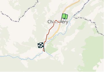
Trail Walking of 1.9 km to be discovered at Valais/Wallis, Monthey, Champéry. This trail is proposed by otchampery.

Description

Am Rande des Dorfes liegt der Chemin des Poussettes, welcher durch den Wald nach Grand-Paradis führt. Dieser Weg eignet sich besonders für jene die nicht mehr ganz so gut zu Fuss sind oder für Familien mit einem Kinderwagen, da es praktisch keinen Höhenunterschied zu bewältigen gibt. Da sich der Weg zum grossen Teil im Wald befindet sind die Spaziergänger auch vor der Sonne oder einem plötzlichen Gewitter geschützt.

Elevation profile

Points of interest

Point of interest Champéry - Départ - Photo
otchampery
CHAMPÉRY 
Point of interest Champéry - Auberge du Grand-Paradis - Photo
otchampery
Point of interest Champéry - Arrivée - Photo
otchampery
CHAMPÉRY 
Point of interest Champéry - Office du Tourisme - Photo
otchampery
Point of interest Champéry - de Lavallaz - Photo
otchampery
CHAMPÉRY 
Point of interest Champéry - Champéry - Photo
otchampery
CHAMPÉRY 
Point of interest Champéry - Champéry TCP - Photo
otchampery
CHAMPÉRY 

Positioning

Country:
Switzerland
Region :
Valais/Wallis
Department/Province :
Monthey
Municipality :
Champéry
Location:
Unknown
Start:(UTM)
335628 ; 5115701 (32T) N.

Trails nearby

Trail On foot Val-d'Illiez - Les Crosets-Sur Cou - Photo
On foot
PRO

On foot

Easy
Val-d'Illiez, Valais/Wallis, Monthey, Switzerland
3.6 km | 4.8 km-effort
1h 6min
No
Trail Walking Val-d'Illiez - Dents de Midi, Lac de Soi - Photo
Walking
rpf

Walking

Very easy
(1)
Val-d'Illiez, Valais/Wallis, Monthey, Switzerland
5.1 km | 9.8 km-effort
2h 30min
Yes
Trail Walking Champéry - Champéry - Die Galérie Défago - Photo
Walking
otchampery

Walking

Very easy
(1)
Champéry, Valais/Wallis, Monthey, Switzerland
10.1 km | 15 km-effort
3h 38min
No
Trail Walking Val-d'Illiez - Lac de Soi - Photo
Walking
bozo1970

Walking

Very difficult
Val-d'Illiez, Valais/Wallis, Monthey, Switzerland
14.6 km | 30 km-effort
5h 19min
Yes
Trail sport Val-d'Illiez - Vtt électrique aux Portes du soleil  - Photo
sport
Alfredy

sport

Very easy
Val-d'Illiez, Valais/Wallis, Monthey, Switzerland
52 km | 81 km-effort
Unknown
Yes
Trail Walking Val-d'Illiez - lac de soi par signal de soi - Photo
Walking
ajpbm

Walking

Difficult
Val-d'Illiez, Valais/Wallis, Monthey, Switzerland
10.4 km | 25 km-effort
4h 5min
Yes
Trail Other activity Samoëns - bdx004_0626 - Photo
Other activity
GUIDE+

Other activity

Very easy
Samoëns, Auvergne-Rhône-Alpes, Upper Savoy, France
23 km | 54 km-effort
13h 34min
No
Trail Walking Champéry - hike33 - Photo
Walking
GUIDE+

Walking

Very easy
Champéry, Valais/Wallis, Monthey, Switzerland
9.1 km | 15.9 km-effort
Unknown
No
Trail Walking Champéry - vs_hike808c - Photo
Walking
GUIDE+

Walking

Very easy
Champéry, Valais/Wallis, Monthey, Switzerland
102 km | 194 km-effort
36h 47min
Yes


Close
My subscriptions