Monthey, Valais/Wallis: Best trails, routes and walks

8 comments

Monthey: Discover the best trails: 114 hiking trails and 46 bike and mountain-bike routes. All these trails, routes and outdoor activities are available in our SityTrail applications for smartphones and tablets.


The best trails (220)

Trail On foot Vouvry - Miex-Lac Tanay (via Prélagine) - Photo
On foot 6.268
Km
PRO

On foot

Easy
Vouvry, Valais/Wallis, Monthey, Switzerland
6.3 km | 9.9 km-effort
2h 15min
162 m
615 m
No
SityTrail - itinéraires balisés pédestres

• Miex-Lac Tanay (via Prélagine) Symbol: Gelbe Raute

Trail On foot Vionnaz - Torgon village - Chalet de Blancsex - Photo
On foot 4.438
Km
PRO

On foot

Easy
Vionnaz, Valais/Wallis, Monthey, Switzerland
4.4 km | 8.7 km-effort
1h 58min
424 m
11 m
No
SityTrail - itinéraires balisés pédestres

• Symbol: losange jaune

Trail On foot Vionnaz - Torgon village - Dravers - Photo
On foot 3.975
Km
PRO

On foot

Easy
Vionnaz, Valais/Wallis, Monthey, Switzerland
4 km | 8.3 km-effort
1h 53min
428 m
11 m
No
SityTrail - itinéraires balisés pédestres

• Symbol: losange jaune

Trail On foot Val-d'Illiez - Les Crosets-Sur Cou - Photo
On foot 3.59
Km
PRO

On foot

Easy
Val-d'Illiez, Valais/Wallis, Monthey, Switzerland
3.6 km | 4.8 km-effort
1h 6min
16 m
328 m
No
SityTrail - itinéraires balisés pédestres

• Symbol: gelbe Raute

Trail Walking Val-d'Illiez - Dents de Midi, Lac de Soi - Photo
Walking 5.122
Km

Walking

Very easy
(1)
Val-d'Illiez, Valais/Wallis, Monthey, Switzerland
5.1 km | 9.8 km-effort
2h 30min
350 m
350 m
Yes
rpf

Trail Walking Champéry - Champéry - Die Galérie Défago - Photo
Walking 10.142
Km

Walking

Very easy
(1)
Champéry, Valais/Wallis, Monthey, Switzerland
10.1 km | 15 km-effort
3h 38min
376 m
342 m
No
otchampery

Trail Walking Val-d'Illiez - Lac de Soi - Photo
Walking 14.628
Km

Walking

Very difficult
Val-d'Illiez, Valais/Wallis, Monthey, Switzerland
14.6 km | 30 km-effort
5h 19min
1175 m
1169 m
Yes
bozo1970

Trail Walking Troistorrents - Morgins - circuit Bonavau, La Truche,La Foilleuse, Savolaire 29.09.18 - Photo
Walking 15.063
Km

Walking

Medium
Troistorrents, Valais/Wallis, Monthey, Switzerland
15.1 km | 23 km-effort
4h 50min
617 m
616 m
Yes
duamerg

Trail Walking Vouvry - Lac Tanay - Photo
Walking 12.383
Km

Walking

Medium
Vouvry, Valais/Wallis, Monthey, Switzerland
12.4 km | 22 km-effort
4h 45min
738 m
719 m
Yes
danihz

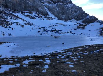
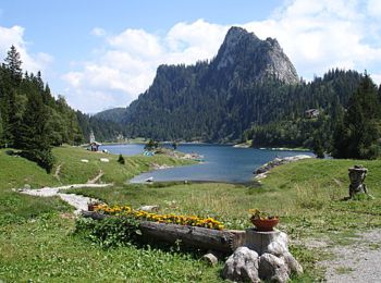
• Lac Tanay par Prélagine

Trail Snowshoes Troistorrents - La Foilleuze - Madzé - Morgins - Photo
Snowshoes 5.105
Km

Snowshoes

Very easy
Troistorrents, Valais/Wallis, Monthey, Switzerland
5.1 km | 7 km-effort
1h 47min
24 m
504 m
No
boisacq

• A faire dans l'autre sens car soleil et superbe apd Madzé

Trail Mountain bike Saint-Gingolph - TransAlpes VTT - 01/25 - St Gingolf - Lac de Tanay - Photo
Mountain bike 13.806
Km

Mountain bike

Difficult
Saint-Gingolph, Valais/Wallis, Monthey, Switzerland
13.8 km | 27 km-effort
2h 30min
1228 m
207 m
No
tracegps

Trail sport Val-d'Illiez - Vtt électrique aux Portes du soleil  - Photo
sport 52.224
Km

sport

Very easy
Val-d'Illiez, Valais/Wallis, Monthey, Switzerland
52 km | 81 km-effort
Unknown
2171 m
2169 m
Yes
Alfredy

Trail Walking Val-d'Illiez - lac de soi par signal de soi - Photo
Walking 10.434
Km

Walking

Difficult
Val-d'Illiez, Valais/Wallis, Monthey, Switzerland
10.4 km | 25 km-effort
4h 5min
1093 m
1089 m
Yes
ajpbm

Trail Other activity Saint-Gingolph - bdx001_0623 - Photo
Other activity 11.259
Km
GUIDE+

Other activity

Very easy
Saint-Gingolph, Valais/Wallis, Monthey, Switzerland
11.3 km | 35 km-effort
8h 5min
2118 m
673 m
No
My Switzerland

Trail Other activity Le Léman (VS) - bdr99_StGingolphe_Leysin - Photo
Other activity 25.875
Km
GUIDE+

Other activity

Very easy
Le Léman (VS), Valais/Wallis, Monthey, Switzerland
26 km | 38 km-effort
8h 59min
1174 m
255 m
No
My Switzerland

Trail Other activity Le Léman (VS) - bdr01_StGingolphe_Trient - Photo
Other activity 68.263
Km
GUIDE+

Other activity

Very easy
Le Léman (VS), Valais/Wallis, Monthey, Switzerland
68 km | 170 km-effort
40h 54min
7818 m
7059 m
No
My Switzerland

Trail Other activity Saint-Gingolph - xxx20_Heremence_StGingolphe - Photo
Other activity 58.78
Km
GUIDE+

Other activity

Very easy
Saint-Gingolph, Valais/Wallis, Monthey, Switzerland
59 km | 59 km-effort
13h 24min
2 m
0 m
No
My Switzerland

Trail Walking Champéry - hike33 - Photo
Walking 9.146
Km
GUIDE+

Walking

Very easy
Champéry, Valais/Wallis, Monthey, Switzerland
9.1 km | 15.9 km-effort
Unknown
480 m
596 m
No
My Switzerland

Trail Mountain bike Troistorrents - Bike32927 - Photo
Mountain bike 53.923
Km
GUIDE+

Mountain bike

Very easy
Troistorrents, Valais/Wallis, Monthey, Switzerland
54 km | 86 km-effort
Unknown
2373 m
2363 m
Yes
My Switzerland

Trail Walking Champéry - vs_hike808c - Photo
Walking 102.207
Km
GUIDE+

Walking

Very easy
Champéry, Valais/Wallis, Monthey, Switzerland
102 km | 194 km-effort
36h 47min
6909 m
6915 m
Yes
My Switzerland

20 trails displayed on 220

FREE GPS app for hiking

Logo SityTrail SityTrail

IGN / Geographical institutes

Download SityTrail from the App Store Download SityTrail from Google Play

Logo SityTrail SityTrail World

The world is yours!

Download SityTrail from the App Store Download SityTrail from Google Play Download SityTrail on Huawei AppGallery

Activities

Nearby regions

Close
My subscriptions