Trail Walking Champéry - Champéry - Sous Sex - Photo
© OpenStreetMap contributors
Length
Length
2.8 km
Max alt
Max alt
1038 m
Uphill gradient
Uphill gradient
109 m
Km-Effort
Km-Effort  
4.2 km
Min alt
Min alt
927 m
Downhill gradient
Downhill gradient
109 m
Boucle
Boucle
Yes
Creation date :
2014-12-11 00:00:00.0
Updated on :
2014-12-11 00:00:00.0

(1 Reviews)

Walking
Walking
57m
Difficulty : Unknown

Scan this QR Code to open this trail in the SityTrail application

FREE GPS app for hiking

Logo SityTrail SityTrail

IGN / Geographical institutes

Download SityTrail from the App Store Download SityTrail from Google Play

Logo SityTrail SityTrail World

The world is yours!

Download SityTrail from the App Store Download SityTrail from Google Play Download SityTrail on Huawei AppGallery

About

Trail Walking of 2.8 km to be discovered at Valais/Wallis, Monthey, Champéry. This trail is proposed by otchampery.

Description

Dieser Spaziergang ist einzigartig für die Region, da man ein ganz besonderes Ökosystem bewundern kann. Er ist ohne grosse Anstrengung zu meistern, da es nur einen geringen Höhenunterschied zu bewältigen gilt. Entdeckens sie diesen Weg, der vor allem an sehr heissen Tagen angenehm kühl ist. Interessant zu wissen ist auch, dass die Möglichkeit besteht dort zu fischen. Tagesanglerscheine sind bei Champéry Tourismus erhältlich.

Elevation profile

Points of interest

Point of interest Champéry - Départ - Photo
otchampery
CHAMPÉRY 
Point of interest Champéry -  - Photo
otchampery
CHAMPÉRY 
Point of interest Champéry - Office du Tourisme - Photo
otchampery
Point of interest Champéry - Champéry - Photo
otchampery
CHAMPÉRY 
Point of interest Champéry - Champéry TCP - Photo
otchampery
CHAMPÉRY 
Point of interest Champéry - Arrivée - Photo
otchampery
CHAMPÉRY 

Positioning

Country:
Switzerland
Region :
Valais/Wallis
Department/Province :
Monthey
Municipality :
Champéry
Location:
Unknown
Start:(UTM)
335628 ; 5115699 (32T) N.

Comments

Please log in to post a review or rate the element


me semble le top. vais essayer d'utiliser avec carte gratuite. @+


Trails nearby

Trail On foot Val-d'Illiez - Les Crosets-Sur Cou - Photo
On foot
PRO

On foot

Easy
Val-d'Illiez, Valais/Wallis, Monthey, Switzerland
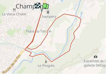
3.6 km | 4.8 km-effort
1h 6min
No
Trail Walking Val-d'Illiez - Dents de Midi, Lac de Soi - Photo
Walking
rpf

Walking

Very easy
(1)
Val-d'Illiez, Valais/Wallis, Monthey, Switzerland
5.1 km | 9.8 km-effort
2h 30min
Yes
Trail Walking Champéry - Champéry - Die Galérie Défago - Photo
Walking
otchampery

Walking

Very easy
(1)
Champéry, Valais/Wallis, Monthey, Switzerland
10.1 km | 15 km-effort
3h 38min
No
Trail Walking Val-d'Illiez - Lac de Soi - Photo
Walking
bozo1970

Walking

Very difficult
Val-d'Illiez, Valais/Wallis, Monthey, Switzerland
14.6 km | 30 km-effort
5h 19min
Yes
Trail sport Val-d'Illiez - Vtt électrique aux Portes du soleil  - Photo
sport
Alfredy

sport

Very easy
Val-d'Illiez, Valais/Wallis, Monthey, Switzerland
52 km | 81 km-effort
Unknown
Yes
Trail Walking Val-d'Illiez - lac de soi par signal de soi - Photo
Walking
ajpbm

Walking

Difficult
Val-d'Illiez, Valais/Wallis, Monthey, Switzerland
10.4 km | 25 km-effort
4h 5min
Yes
Trail Other activity Samoëns - bdx004_0626 - Photo
Other activity
GUIDE+

Other activity

Very easy
Samoëns, Auvergne-Rhône-Alpes, Upper Savoy, France
23 km | 54 km-effort
13h 34min
No
Trail Walking Champéry - hike33 - Photo
Walking
GUIDE+

Walking

Very easy
Champéry, Valais/Wallis, Monthey, Switzerland
9.1 km | 15.9 km-effort
Unknown
No
Trail Walking Champéry - vs_hike808c - Photo
Walking
GUIDE+

Walking

Very easy
Champéry, Valais/Wallis, Monthey, Switzerland
102 km | 194 km-effort
36h 47min
Yes


Close
My subscriptions