


Ursuya depuis Zelaia

FERREREMARC
User
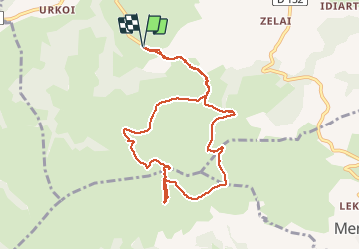

Length
9.7 km

Max alt
671 m

Uphill gradient
440 m
Km-Effort
15.6 km

Min alt
253 m

Downhill gradient
445 m
Boucle
Yes
Creation date :
2020-03-15 10:01:04.055
Updated on :
2020-03-15 13:53:33.178
3h51
Difficulty : Very easy

FREE GPS app for hiking
 SityTrail
IGN / Geographical institutes
SityTrail Plus
The world is yours!
About
Trail Walking of 9.7 km to be discovered at New Aquitaine, Pyrénées-Atlantiques, Hasparren. This trail is proposed by FERREREMARC.
Positioning
Country:
France
Region :
New Aquitaine
Department/Province :
Pyrénées-Atlantiques
Municipality :
Hasparren
Location:
Unknown
Start:(Dec)
Start:(UTM)
634683 ; 4802462 (30T) N.
Comments