


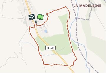
Boucle des Pres Gris

claude nier
User

Length
4.7 km

Max alt
520 m

Uphill gradient
47 m
Km-Effort
5.3 km

Min alt
486 m

Downhill gradient
43 m
Boucle
Yes
Creation date :
2020-03-15 13:52:50.891
Updated on :
2020-03-15 15:23:51.299
1h19
Difficulty : Easy

FREE GPS app for hiking
 SityTrail
IGN / Geographical institutes
SityTrail Plus
The world is yours!
About
Trail Walking of 4.7 km to be discovered at Provence-Alpes-Côte d'Azur, Hautes-Alpes, Val-Buëch-Méouge. This trail is proposed by claude nier.
Description
petite rando sympa..
Positioning
Country:
France
Region :
Provence-Alpes-Côte d'Azur
Department/Province :
Hautes-Alpes
Municipality :
Val-Buëch-Méouge
Location:
Unknown
Start:(Dec)
Start:(UTM)
728544 ; 4900680 (31T) N.
Comments