


Heimsbrunn

ROPPJP
User
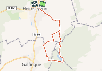

Length
7.8 km

Max alt
308 m

Uphill gradient
95 m
Km-Effort
9.1 km

Min alt
280 m

Downhill gradient
95 m
Boucle
Yes
Creation date :
2020-03-15 15:07:40.6
Updated on :
2020-03-15 19:19:13.965
1h45
Difficulty : Very easy

FREE GPS app for hiking
 SityTrail
IGN / Geographical institutes
SityTrail Plus
The world is yours!
About
Trail Walking of 7.8 km to be discovered at Grand Est, Haut-Rhin, Heimsbrunn. This trail is proposed by ROPPJP.
Photos

Positioning
Country:
France
Region :
Grand Est
Department/Province :
Haut-Rhin
Municipality :
Heimsbrunn
Location:
Unknown
Start:(Dec)
Start:(UTM)
367132 ; 5287437 (32T) N.
Comments