


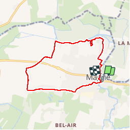
Magné (tour de Magné) 7Km

olaze
User

Length
7 km

Max alt
19 m

Uphill gradient
36 m
Km-Effort
7.5 km

Min alt
3 m

Downhill gradient
36 m
Boucle
Yes
Creation date :
2014-12-10 00:00:00.0
Updated on :
2014-12-10 00:00:00.0
1h45
Difficulty : Unknown

FREE GPS app for hiking
 SityTrail
IGN / Geographical institutes
SityTrail Plus
The world is yours!
About
Trail Walking of 7 km to be discovered at New Aquitaine, Deux-Sèvres, Magné. This trail is proposed by olaze.
Description
Départ & retour parking tennis.
Tour de Magné .
Club rando Bessines*. déc 2013


Positioning
Country:
France
Region :
New Aquitaine
Department/Province :
Deux-Sèvres
Municipality :
Magné
Location:
Unknown
Start:(Dec)
Start:(UTM)
689274 ; 5131846 (30T) N.
Comments