


Remomont deux têtes

vaillantjm
User

Length
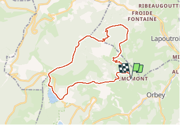
17.2 km

Max alt
1215 m

Uphill gradient
888 m
Km-Effort
29 km

Min alt
590 m

Downhill gradient
888 m
Boucle
Yes
Creation date :
2020-04-04 13:36:48.485
Updated on :
2020-04-04 13:51:20.166
6h00
Difficulty : Very difficult

FREE GPS app for hiking
 SityTrail
IGN / Geographical institutes
SityTrail Plus
The world is yours!
About
Trail Walking of 17.2 km to be discovered at Grand Est, Haut-Rhin, Orbey. This trail is proposed by vaillantjm.
Positioning
Country:
France
Region :
Grand Est
Department/Province :
Haut-Rhin
Municipality :
Orbey
Location:
Unknown
Start:(Dec)
Start:(UTM)
361992 ; 5332913 (32U) N.
Comments