Trail Walking Caupenne-d'Armagnac - Caupenne d'armagnac  - Photo

Caupenne d'armagnac

 DuMarsan
DuMarsan

User

© OpenStreetMap contributors
Length
Length
12 km
Max alt
Max alt
146 m
Uphill gradient
Uphill gradient
131 m
Km-Effort
Km-Effort  
13.8 km
Min alt
Min alt
84 m
Downhill gradient
Downhill gradient
130 m
Boucle
Boucle
Yes
Creation date :
2014-12-10 00:00:00.0
Updated on :
2014-12-10 00:00:00.0

(0 Reviews)

Walking
Walking
2h25
Difficulty : Easy

Scan this QR Code to open this trail in the SityTrail application

FREE GPS app for hiking

Logo SityTrail SityTrail

IGN / Geographical institutes

Download SityTrail from the App Store Download SityTrail from Google Play

Logo SityTrail SityTrail World

The world is yours!

Download SityTrail from the App Store Download SityTrail from Google Play Download SityTrail on Huawei AppGallery

About

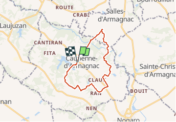
Trail Walking of 12 km to be discovered at Occitania, Gers, Caupenne-d'Armagnac. This trail is proposed by DuMarsan.

Description

Tour de Caupenne=Issu du topoguide "le pays d' armagnac à pied": rando agréable mais mal balisée ( 3 points incertains sans fléchage )rendue plus facile par ce sityguide.Carte et Gps préférables.

Elevation profile

Positioning

Country:
France
Region :
Occitania
Department/Province :
Gers
Municipality :
Caupenne-d'Armagnac
Location:
Unknown
Start:(UTM)
735866 ; 4852573 (30T) N.

Trails nearby

Trail Walking Nogaro - GR 65 Nogaro > Aire sur Adour - Photo
Walking
choubaka77

Walking

Difficult
Nogaro, Occitania, Gers, France
26 km | 30 km-effort
6h 57min
No
Trail Walking Nogaro - 3 Nogaro - Photo
Walking
GUIDE
thonyc

Walking

Difficult
Nogaro, Occitania, Gers, France
28 km | 33 km-effort
8h 1min
No
Trail Walking Nogaro - Camino 1 étape 25 du 20.08.2023 - Photo
Walking
bene_dictus77

Walking

Medium
Nogaro, Occitania, Gers, France
29 km | 34 km-effort
7h 44min
No
Trail Walking Nogaro - StJ-J38-Nogaro-Aire sur l'Adour - Photo
Walking
Bonsaicd

Walking

Very difficult
Nogaro, Occitania, Gers, France
28 km | 32 km-effort
6h 52min
No
Trail Walking Nogaro - OR-6947751--Nogaro:Nogaro-Lelin-Lapujolle-arblade le bas-7 - Photo
Walking
Compostel61

Walking

Very easy
(1)
Nogaro, Occitania, Gers, France
21 km | 25 km-effort
5h 25min
No
Trail Walking Nogaro - Compostelle 26 - Nogaro -> Aire-sur-l'Adour - Photo
Walking
uru2010

Walking

Medium
Nogaro, Occitania, Gers, France
29 km | 33 km-effort
7h 5min
No
Trail Walking Nogaro - Nogaro-Aire sur l'Adour - Photo
Walking
chouk1

Walking

Difficult
Nogaro, Occitania, Gers, France
29 km | 34 km-effort
7h 25min
No
Trail Bicycle tourism Nogaro - B - Nogaro - La route de l'Armagnac - Photo
Bicycle tourism
potofe

Bicycle tourism

Medium
Nogaro, Occitania, Gers, France
94 km | 109 km-effort
Unknown
Yes
Trail Walking Lanne-Soubiran - presbytère-Aire sur l'Adour  - Photo
Walking
bernard.bonafous@free.fr

Walking

Very difficult
Lanne-Soubiran, Occitania, Gers, France
21 km | 23 km-effort
4h 46min
No


Close
My subscriptions