


HeimsbrunnGalRetout

ROPPJP
User
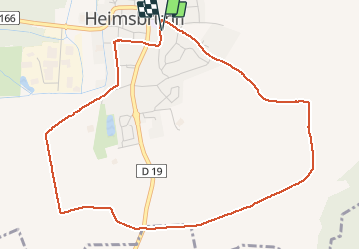

Length
5.2 km

Max alt
305 m

Uphill gradient
50 m
Km-Effort
5.9 km

Min alt
265 m

Downhill gradient
51 m
Boucle
Yes
Creation date :
2020-04-13 05:53:42.033
Updated on :
2020-04-13 09:53:55.53
1h03
Difficulty : Very easy

FREE GPS app for hiking
 SityTrail
IGN / Geographical institutes
SityTrail Plus
The world is yours!
About
Trail Walking of 5.2 km to be discovered at Grand Est, Haut-Rhin, Heimsbrunn. This trail is proposed by ROPPJP.
Photos

Positioning
Country:
France
Region :
Grand Est
Department/Province :
Haut-Rhin
Municipality :
Heimsbrunn
Location:
Unknown
Start:(Dec)
Start:(UTM)
367133 ; 5287441 (32T) N.
Comments