


Corona10

jmbilger
User
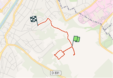

Length
2.6 km

Max alt
325 m

Uphill gradient
29 m
Km-Effort
3.1 km

Min alt
292 m

Downhill gradient
52 m
Boucle
No
Creation date :
2020-04-16 14:09:04.0
Updated on :
2020-04-16 14:49:55.651
41m
Difficulty : Unknown

FREE GPS app for hiking
 SityTrail
IGN / Geographical institutes
SityTrail Plus
The world is yours!
About
Trail Walking of 2.6 km to be discovered at Grand Est, Haut-Rhin, Brunstatt-Didenheim. This trail is proposed by jmbilger.
Positioning
Country:
France
Region :
Grand Est
Department/Province :
Haut-Rhin
Municipality :
Brunstatt-Didenheim
Location:
Brunstatt
Start:(Dec)
Start:(UTM)
375180 ; 5286406 (32T) N.
Comments