


la teure

JPS73
User
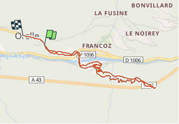

Length
5.6 km

Max alt
1101 m

Uphill gradient
341 m
Km-Effort
10 km

Min alt
866 m

Downhill gradient
302 m
Boucle
No
Creation date :
2020-04-23 12:35:42.91
Updated on :
2020-04-23 14:21:59.647
1h42
Difficulty : Medium

FREE GPS app for hiking
 SityTrail
IGN / Geographical institutes
SityTrail Plus
The world is yours!
About
Trail Walking of 5.6 km to be discovered at Auvergne-Rhône-Alpes, Savoy, Orelle. This trail is proposed by JPS73.
Positioning
Country:
France
Region :
Auvergne-Rhône-Alpes
Department/Province :
Savoy
Municipality :
Orelle
Location:
Unknown
Start:(Dec)
Start:(UTM)
306691 ; 5009064 (32T) N.
Comments