


Rivière d'Angoustrine

PaulNord
User
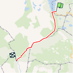

Length
7.4 km

Max alt
2021 m

Uphill gradient
17 m
Km-Effort
9 km

Min alt
1598 m

Downhill gradient
429 m
Boucle
No
Creation date :
2014-12-10 00:00:00.0
Updated on :
2014-12-10 00:00:00.0
2h00
Difficulty : Unknown

FREE GPS app for hiking
 SityTrail
IGN / Geographical institutes
SityTrail Plus
The world is yours!
About
Trail Winter sports of 7.4 km to be discovered at Occitania, Pyrénées-Orientales, Les Angles. This trail is proposed by PaulNord.
Positioning
Country:
France
Region :
Occitania
Department/Province :
Pyrénées-Orientales
Municipality :
Les Angles
Location:
Unknown
Start:(Dec)
Start:(UTM)
418217 ; 4712458 (31T) N.
Comments