Trail Other activity Hochwald - BL Hochwald / Herrenmatt - Photo

BL Hochwald / Herrenmatt

 hrb
hrb

User

© OpenStreetMap contributors
Length
Length
8.4 km
Max alt
Max alt
702 m
Uphill gradient
Uphill gradient
281 m
Km-Effort
Km-Effort  
12.2 km
Min alt
Min alt
594 m
Downhill gradient
Downhill gradient
274 m
Boucle
Boucle
Yes
Creation date :
2014-12-11 00:00:00.0
Updated on :
2014-12-11 00:00:00.0

(0 Reviews)

Other activity
Other activity
--
Difficulty : Unknown

Scan this QR Code to open this trail in the SityTrail application

FREE GPS app for hiking

Logo SityTrail SityTrail

IGN / Geographical institutes

Download SityTrail from the App Store Download SityTrail from Google Play

Logo SityTrail SityTrail World

The world is yours!

Download SityTrail from the App Store Download SityTrail from Google Play Download SityTrail on Huawei AppGallery

About

Trail Other activity of 8.4 km to be discovered at Solothurn, Bezirk Dorneck, Hochwald. This trail is proposed by hrb.

Description

Seelein schön mit Rasplatz

Grotte: steiler Abstieg, Taschenlampe, Jacke

Elevation profile

Positioning

Country:
Switzerland
Region :
Solothurn
Department/Province :
Bezirk Dorneck
Municipality :
Hochwald
Location:
Unknown
Start:(UTM)
397417 ; 5257624 (32T) N.

Trails nearby

Trail On foot Büren (SO) - Büren - Nuglar - Photo
On foot
PRO

On foot

Easy
Büren (SO), Solothurn, Bezirk Dorneck, Switzerland
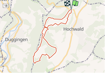
4 km | 6.2 km-effort
1h 24min
No
Trail On foot Hochwald - Herrenmatt - Woll - fixme - Photo
On foot
PRO

On foot

Easy
Hochwald, Solothurn, Bezirk Dorneck, Switzerland
3.2 km | 4.6 km-effort
1h 3min
No
Trail On foot Hochwald - Hochwald Post - Musikschule - Photo
On foot
PRO

On foot

Easy
Hochwald, Solothurn, Bezirk Dorneck, Switzerland
3.9 km | 6.1 km-effort
1h 23min
No
Trail On foot Hochwald - Hochwald Post - Büren - Photo
On foot
PRO

On foot

Easy
Hochwald, Solothurn, Bezirk Dorneck, Switzerland
3.5 km | 5.3 km-effort
1h 12min
No
Trail On foot Hochwald - Herrenmatt - Musikschule - Photo
On foot
PRO

On foot

Easy
Hochwald, Solothurn, Bezirk Dorneck, Switzerland
3.4 km | 5.3 km-effort
1h 12min
No
Trail On foot Aesch - Aesch - Herrenmatt - Photo
On foot
PRO

On foot

Easy
Aesch, Basel-Landschaft, Bezirk Arlesheim, Switzerland
3 km | 6.3 km-effort
1h 25min
No
Trail On foot Liestal - Muni - Liestal (via Summerholden) - Photo
On foot
PRO

On foot

Easy
Liestal, Basel-Landschaft, Bezirk Liestal, Switzerland
4.4 km | 5.5 km-effort
1h 14min
No
Trail On foot Nuglar-St. Pantaleon - Nuglar - Bintal - fixme - Photo
On foot
PRO

On foot

Easy
Nuglar-St. Pantaleon, Solothurn, Bezirk Dorneck, Switzerland
3.1 km | 4.1 km-effort
56min
No
Trail Walking Grellingen - Kaltbrunnental: Grellingen BL - Meltingen BL - Photo
Walking
GUIDE+

Walking

Very easy
Grellingen, Basel-Landschaft, Bezirk Laufen, Switzerland
8.9 km | 12.9 km-effort
Unknown
No


Close
My subscriptions