Trail Other activity Bullet - VB Chasseron 2 - Photo
 hrb
hrb

User

© OpenStreetMap contributors
Length
Length
11.5 km
Max alt
Max alt
1584 m
Uphill gradient
Uphill gradient
438 m
Km-Effort
Km-Effort  
17.4 km
Min alt
Min alt
1206 m
Downhill gradient
Downhill gradient
438 m
Boucle
Boucle
Yes
Creation date :
2014-12-11 00:00:00.0
Updated on :
2014-12-11 00:00:00.0

(0 Reviews)

Other activity
Other activity
--
Difficulty : Unknown

Scan this QR Code to open this trail in the SityTrail application

FREE GPS app for hiking

Logo SityTrail SityTrail

IGN / Geographical institutes

Download SityTrail from the App Store Download SityTrail from Google Play

Logo SityTrail SityTrail World

The world is yours!

Download SityTrail from the App Store Download SityTrail from Google Play Download SityTrail on Huawei AppGallery

About

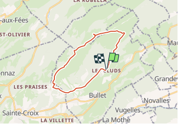
Trail Other activity of 11.5 km to be discovered at Vaud, District du Jura-Nord vaudois, Bullet. This trail is proposed by hrb.

Description

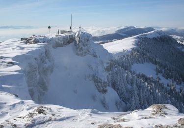
Von burg an ist es stotzig bis zur Challhöhe. Der Gratweg ist schön. Aussichtspunkt auf 800müM

Elevation profile

Positioning

Country:
Switzerland
Region :
Vaud
Department/Province :
District du Jura-Nord vaudois
Municipality :
Bullet
Location:
Unknown
Start:(UTM)
314036 ; 5190646 (32T) N.

Trails nearby

Trail On foot Val-de-Travers - Petite Robella - Hôtel du Chasseron - Photo
On foot
PRO

On foot

Easy
Val-de-Travers, Neuchâtel, Unknown, Switzerland
4.5 km | 8.3 km-effort
1h 52min
No
Trail On foot Val-de-Travers - Petite Robella - Hôtel du Chasseron - Photo
On foot
PRO

On foot

Easy
Val-de-Travers, Neuchâtel, Unknown, Switzerland
4.4 km | 8.4 km-effort
1h 55min
No
Trail On foot Sainte-Croix - Sainte Croix-La Gittaz - Photo
On foot
PRO

On foot

Easy
Sainte-Croix, Vaud, District du Jura-Nord vaudois, Switzerland
5.7 km | 8.3 km-effort
1h 53min
No
Trail On foot Sainte-Croix - Chemin de la Gare - Photo
On foot
PRO

On foot

Easy
Sainte-Croix, Vaud, District du Jura-Nord vaudois, Switzerland
6.5 km | 8.6 km-effort
1h 57min
No
Trail Walking Sainte-Croix - le Chasseron par les avattes - Photo
Walking
viam19

Walking

Medium
Sainte-Croix, Vaud, District du Jura-Nord vaudois, Switzerland
13.3 km | 20 km-effort
4h 18min
Yes
Trail On foot Bullet - Les Cernets Dessous-La Combaz - Photo
On foot
PRO

On foot

Easy
Bullet, Vaud, District du Jura-Nord vaudois, Switzerland
5.7 km | 8.4 km-effort
1h 54min
No
Trail On foot Bullet - Les Cernets Dessus-Pouetta Raisse - Photo
On foot
PRO

On foot

Easy
Bullet, Vaud, District du Jura-Nord vaudois, Switzerland
6.4 km | 9.2 km-effort
2h 5min
No
Trail Walking Sainte-Croix - hike10 - Photo
Walking
GUIDE+

Walking

Very easy
Sainte-Croix, Vaud, District du Jura-Nord vaudois, Switzerland
23 km | 34 km-effort
Unknown
No
Trail Walking Sainte-Croix - wa14 - Photo
Walking
GUIDE+

Walking

Very easy
Sainte-Croix, Vaud, District du Jura-Nord vaudois, Switzerland
4.8 km | 6.7 km-effort
Unknown
No


Close
My subscriptions