


SAPENAY: LA CHAMBOTTE - CESSENS 20200516

djeepee74
User
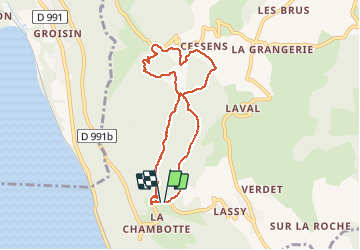

Length
7.2 km

Max alt
838 m

Uphill gradient
302 m
Km-Effort
11.2 km

Min alt
599 m

Downhill gradient
300 m
Boucle
Yes
Creation date :
2020-05-16 19:22:43.335
Updated on :
2020-05-16 19:29:24.127
2h15
Difficulty : Easy

FREE GPS app for hiking
 SityTrail
IGN / Geographical institutes
SityTrail Plus
The world is yours!
About
Trail Walking of 7.2 km to be discovered at Auvergne-Rhône-Alpes, Savoy, Entrelacs. This trail is proposed by djeepee74.
Description
BOUCLE
Positioning
Country:
France
Region :
Auvergne-Rhône-Alpes
Department/Province :
Savoy
Municipality :
Entrelacs
Location:
Saint-Germain-la-Chambotte
Start:(Dec)
Start:(UTM)
723617 ; 5073581 (31T) N.
Comments